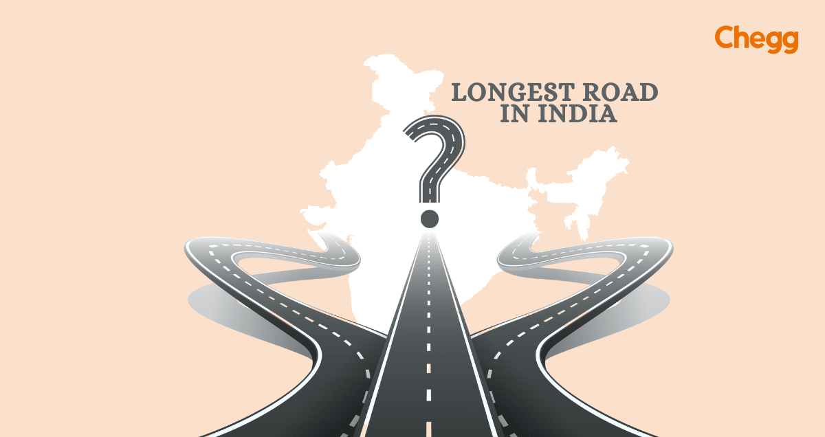
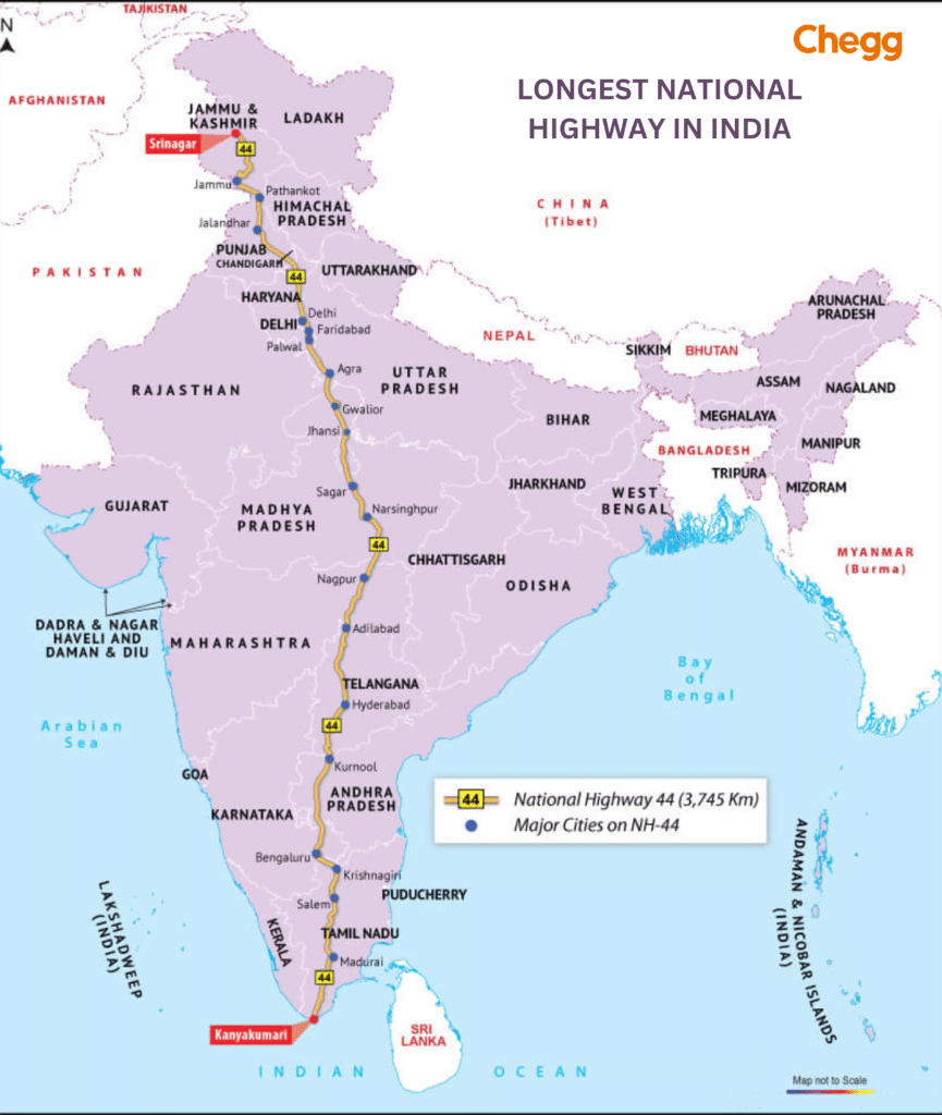
In a country where every 50 kilometers brings a new dialect and culture, National Highway 44 (NH 44), the longest road in India, offers a journey like no other. Stretching 3,745 kilometers from Srinagar in the north to Kanyakumari in the south, this longest road in India takes you through a stunning array of landscapes—from snow-capped mountains to sun-drenched beaches and bustling cities to peaceful villages. The longest road in India isn’t just a highway; it’s an adventure through the heart of India, showcasing the country’s rich heritage, diverse cultures, and vibrant life. Buckle up for an unforgettable ride on the longest road in India and experience the incredible diversity that defines this nation!
As the longest road in India, NH 44 plays a crucial role in facilitating trade, travel, and regional connectivity. It is more than just a highway—it is a route that unites the country, showcasing its cultural richness, vibrant diversity, and natural beauty.
Of the numerous highways in India, the longest road in India is National Highway 44 (NH 44). As you travel along this longest road in India, you’ll be captivated by the serene beauty that unfolds at every turn. From snow-capped mountains to lush plains, the longest road in India offers some of the most jaw-dropping landscapes that are truly the USP of this highway. Whether you’re crossing bustling cities or peaceful villages, the longest road in India gives you a unique glimpse into the country’s diverse and picturesque terrains. Buckle up for an unforgettable ride on the longest road in India, where each kilometer is a new adventure.
From the snow-clad roads of Srinagar to the sound of the ocean crashing against the rock at Kanyakumari, the NH 44 highway is the Longest road in India in km, covering a total distance of around 3745 Kilometers; the whole NH 44 length connects the north of the country to the extreme south. So, it is very important to connect the wheat of the north and the rice of the south from the rest of the country. The national highways in India are then used to distribute the products to each nook and corner of the country.
Of all the Highways in India, the NH44 Route or Grand Trunk Road is the longest road in India & the most important of all. It is not only a support system for transporting agricultural products and industrial output to the rest of the country. As India is surrounded by sea from three sides, this highway works as an expediting platform for sending relief material in case of natural calamities.
The route through which the longest road in India passes has historical relevance. The magnificent forts in Madhya Pradesh are said to add to the grandeur of the national highway.
NH 44, the longest road in India, is not just a highway; it has played a transformative role in the country’s development. This longest highway in India is a vital link for farmers, enabling them to transport their produce to markets and ultimately reach the end user. It has been a critical enabler of economic growth, connecting rural areas to urban hubs. The longest road in India also passes through significant religious landmarks, including Madurai and Mathura, Lord Krishna’s birthplace, making it a conduit for commerce and a spiritual path. For those traveling along the longest road in India, this highway offers a journey through economic importance and divine history.
NH 44 Route, the longest national highway in India, traverses 11 states (as of 2024).
Here’s a breakdown of the states NH 44 passes through:
The longest highway in India, National Highway 44 (NH 44), runs from Srinagar in Jammu & Kashmir to Kanyakumari in Tamil Nadu, connecting major cities and boosting the nation’s economy. The route covers:
This highway connects northern, central, and southern India, passing through important cities like Delhi, Agra, Nagpur, Hyderabad, Bengaluru, and Madurai.
The National Highways Authority of India (NHAI) plays a pivotal role in the development, maintenance, and management of national highways across the country. It operates under the Ministry of Road Transport and Highways.
2. Establishment:
The National Highways Authority of India Act of 1988 established NHAI and formalized its role in developing road infrastructure in India.
3. Governance:
It operates under the administrative control of the Ministry of Road Transport and Highways (MoRTH), ensuring smooth governance and policy implementation.
India has the second-largest road network in the world. The National Highways, which comprise only 1.8% of all Indian roads, carry about 40% of the country’s road traffic. Here are the top 10 longest roads in India:
| Rank | Highway Name | Start & End Points | Distance (km) | Nicknames | Interesting Facts |
| 1 | NH 44 (Previously NH 7) | Srinagar, J&K – Kanyakumari, TN | 3,745 | Grand Trunk Road | Crosses the entire country, North to South |
| 2 | NH 27 | Porbandar, Gujarat – Silchar, Assam | 3,507 | Trans-India Highway | Connects West coast to Northeast India |
| 3 | NH 48 (Previously NH 8) | Delhi – Chennai | 2,807 | Delhi-Chennai National Highway | Major artery for North-South travel |
| 4 | NH 52 | Sangrur, Punjab – Ibrahimpatnam, AP | 2,317 | Crucial link for North & East India | |
| 5 | NH 30 (Previously NH 221) | Sitarganj, Uttarakhand – Ibrahimpatnam, AP | 2,040 | Deoria Bypass-NH 6 Connecting Road | Less crowded compared to others |
| 6 | NH 6 | Jorabat, Meghalaya – Selling, Mizoram | 1,873 | East-West Corridor | Connects Northeastern states |
| 7 | NH 53 | Hazira, Gujarat – Pradip Port, Odisha | 1,781 | Surat-Hazira Road | Important for transportation to ports |
| 8 | NH 16 (Previously NH 5) | Kolkata, WB – Chennai, TN | 1,711 | Chennai-Kolkata Highway | Major route on the East Coast |
| 9 | NH 66 (Previously NH 17) | Panvel, Maharashtra – Kanyakumari, TN | 1,622 | Mumbai-Goa-Kerala Highway | Scenic highway, popular for road trips |
| 10 | NH 19 | Delhi – Amritsar | 1,435 | Delhi-Amritsar Highway | Connects Delhi to the holy city of Amritsar |
India boasts 599 highways, including both state and National highways. This is the astounding total number of highways that the nation has and is ever-expanding. The Indian Government has made it its mission to make the national highways an advantage to India and help it achieve its aim of global domination.
The National Highway Authority of India (NHAI) is at the epicenter of the government’s mission to modernize the national highways. Its main objective is to maintain and expand the national highways for better vehicle movement throughout the country. The NHAI was set up by a special Act through the Parliament of India in 1988, and it works day and night to keep our highways safe.
These national highways are the base of the pyramid on which the Indian economy stands. As almost 70% of India’s population lives in villages and their primary source of income is agriculture, the national highways help the farmers sell their stock at the nearest markets. National highways are a lifeline for transport, which cannot be questioned.
Ever dreamt of a road trip that traverses an entire country? Well, in India, that dream can become a reality! As of 2024, the title of longest national highway in India 2024 (and the longest road in India) belongs to the mighty NH 44, also known historically as NH 7. This incredible highway stretches an impressive 3,745 kilometers (2,327 miles), making it a true champion in terms of distance.
The NH 44 Route, nicknamed the “Grand Trunk Road,” is the longest road in India and cuts like a ribbon across the heart of India. Imagine starting your journey amidst the majestic Himalayas of Jammu and Kashmir, with snow-capped peaks as your companions. As you travel southward, the landscape transforms, revealing vibrant cities, rolling plains, and finally, the sun-drenched beaches of Kanyakumari, the southernmost tip of mainland India.
Here’s what makes NH 44 Route so special:
While NH 44 Route reigns supreme in terms of national highways, it’s worth mentioning that India also has a growing network of expressways. These are typically high-speed, controlled-access roads designed for long-distance travel. Currently, the longest expressway in India is the Agra-Lucknow Expressway. Still, with India’s infrastructure development continuing rapidly, this may change.
NH 44 (Grand Trunk Road) is the longest road in India, and it’s more than just a road – it’s a journey that lets you discover the true essence of India. Stretching across diverse landscapes and cultures, this longest highway in India connects the northern and southern parts of the country, offering travelers an unforgettable experience. Whether you’re passing through bustling cities, serene villages, or historical landmarks, the longest road in India encapsulates India’s rich heritage and vibrant life. So, pack your bags, hit the gas, and get ready to conquer the longest road in India on an adventure like no other!
Now, let’s take a closer look at the details of the NH 44 Route. It is 4112 kilometers long and passes through 12 states, which is something we don’t see every day. It passes through most of the country’s important states and has its place in the country’s geography.
If we are to compare our very own NH44 highways with other major highways worldwide, the first one that comes to notice is US Route 20. It covers a total of 3365 miles, which is 5415 kilometers long. it starts in Boston and runs through over a dozen states until Newport in Oregon.
Understand that NH 44 strategically connects the north to the south of the country. The highway bridges the gap between the different food habits of both extremes
India’s vast network of national highways connects cities, towns, and villages. But not all highways are created equal! While some stretch for hundreds or even thousands of kilometers, others serve a vital purpose much more compactly. Let’s zoom in on the title holders for the shortest national highways in India.
There’s a bit of a tie for the title of the shortest national highway! Here are the two contenders:
This tiny titan is only 5 kilometers (3.1 miles) long. It traverses the state of Maharashtra, acting as a spur (short branch) connecting with the larger NH 48. Despite its short distance, NH 548 plays a crucial role in facilitating the movement of people and goods within the region.
NH 118 is just 5 kilometers (3.1 miles) long and located in the state of Jharkhand. It connects the towns of Asanbani and Jamshedpur, serving as a vital link for local traffic and commerce.
While these highways may not be record breakers in terms of distance, they are nonetheless significant for the areas they serve. They demonstrate how even a short stretch of road can play a big role in connecting communities and supporting economic activity.
Here are some interesting facts about short national highways:
So, next time you’re on a road trip to India, look for these short national highways! They may be small in stature, but they are significant in the grand scheme of things.
Concerning Earth’s longest and most remarkable roads, the Pan-American Highway takes the crown. Spanning an astounding 30,000 kilometers (19,000 miles), this iconic route stretches from Prudhoe Bay in Alaska to Ushuaia in Argentina, making it the longest motorable road in the world.
The highway traverses through 14 countries across North, Central, and South America, offering a unique opportunity to experience various climates, cultures, and landscapes. From the icy expanse of Alaska to the tropical rainforests of Central America and the rugged mountains of the Andes, this highway offers a breathtaking journey through the natural wonders of the Americas.
One of the Pan-American Highway’s most intriguing features is the Darien Gap, a roughly 100-mile stretch of impassable terrain between Panama and Colombia. Due to its challenging geography, travelers cannot drive through this part of the highway, making it the only break in the continuous road. However, bypassing this gap is possible through ferry services transporting vehicles across the region.
For adventure enthusiasts, the Pan-American Highway represents more than just a road—it’s a journey of discovery, linking diverse cultures and natural wonders along its vast length. Whether you’re driving through the rugged terrains of the Rockies, the breathtaking landscapes of Patagonia, or the bustling cities of the Americas, this highway offers an unparalleled experience.
The Pan-American Highway is not just a road; it’s a testament to human engineering. It connects the vast and varied landscapes of the Americas and offers adventurers a once-in-a-lifetime opportunity to drive through some of the most stunning and diverse places on Earth.
National highways in India are a major contributor to the country’s overall growth. They are not just a major contributor to the transportation of all kinds of goods, which is the base of the Indian economy. Still, they also connect to major tourist destinations.
With NHAI going into an ultra mode for developing highways, it is a major organization that is always hiring for its ongoing projects. It also allows for smooth facilitation for trade and industry.
If one looks at the Western Expressway or the Yamuna Expressway, it has shortened the travel time between major cities by almost half. Similarly, the longest highway in India, National Highway 44 (NH 44), has revolutionized long-distance travel, making journeys quicker and more convenient than ever. Connecting regions has become incredibly convenient with the development of major expressways, and with the widening of highways to 6 or even 8 lanes, traveling long distances, especially on the longest road in India, is now a smooth and efficient experience. The expansion of infrastructure, including the longest road in India, has revolutionized travel, turning what once seemed like a long journey into a piece of cake.
Suppose one looks at how the roadways have transitioned from independence to the present day. In that case, it has come a long way from the basic roads made from soil or mud to the modern-day roads which can challenge any modern nation regarding infrastructure development.
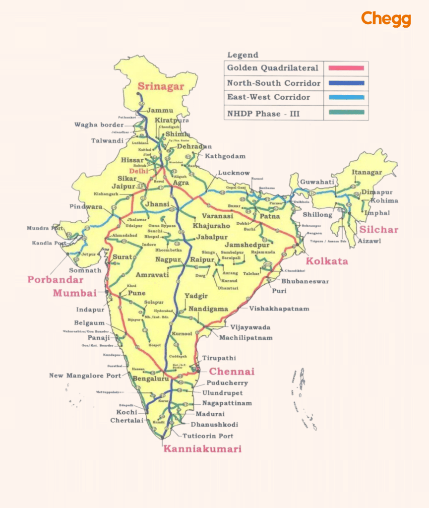
The transition from the traditional to the modern look of Indian highways has not been an easy ride. The nation has faced hurdles when it came to building proper highways. The traditional roads have given way to the north-south and east-west corridors.
Today, asphalt is a major ingredient in making proper roads. Recycled asphalt, warm mix asphalt, and cold mix asphalt are some ingredients that are making Indian roads even more dependable. One other factor that is an advantage over previous traditional methods is the use of nanotechnology and self-healing material that gives the longevity of the road.
Let’s just look beyond the roads and explore how we move around in India. Our country’s transportation system involves more than just roads; it constitutes a complete interconnected system. Highways are just a part of the whole transportation system. The railway network is the other factor that is almost as important as the highways. The Indian railway network is the largest in the world. There are also the ports and the airports not to miss out on.
Trains and planes are more efficient modes of transportation for distance travel and international transportation. Trains can carry much heavier goods and travel at a faster pace than roads. Roads support air and rail transportation by delivering goods to the nearest railway station or airport.
The unique integrated transport system collaborates between air, train, and road travel by highways, ensuring goods reach their destination as quickly as possible by utilizing the fastest means of travel.
The national highways of India are a connector between different regions. The Northeast of the country is one such region where the national highways play a vital role in supplying goods from across the country.
The highways in India are responsible for connecting the most remote and underdeveloped areas of the country. The government will ensure that every village in the country is connected through a network of highways.
The highways bridge the vast differences in cultures across the country as tourists and people from other parts of the country visit tourist locations. This results in an exchange of cultures, bringing together a unique mix of many cultures in one place.
To conclude, no nation can truly progress unless its roads empower it to do so. Roads are more than just physical pathways—they are the lifelines of a country. They connect remote villages to thriving cities, bring businesses closer to consumers, and ensure that opportunities travel far and wide. A well-developed road network, like NH 44—the longest road in India—not only supports commerce, tourism, and logistics but also fuels dreams, aspirations, and livelihoods.
The condition and reach of a nation’s roads reflect its priorities, its development goals, and its global standing. In many ways, the strength of a nation can be measured by the strength of its infrastructure. Roads might not always be in the spotlight, but they are the foundation upon which economies grow, societies evolve, and futures are built.
Investing in roads is investing in progress. Because when roads flourish, nations move forward—faster, stronger, and more united.
Also Read:-
National highways are big highways that help us travel long distances quickly and safely.
The National Highway Authority of India, or NHAI, is responsible for building and maintaining these highways.
Highways make it easier to transport goods, which boosts trade and creates jobs. They also connect people to jobs, schools, and markets, which help our economy grow.
Yes, there are challenges like bad weather and heavy traffic that can wear down roads.
We’re building eco-friendly roads, using technology to make travel better, and creating smart cities that rely on efficient roads.
NH 44, the longest highway in India, connects Kashmir to Kanyakumari, uniting diverse regions and boosting trade, tourism, and national development.
The Pan-American Highway is considered the world’s longest “motorable road.” It stretches from Prudhoe Bay, Alaska, to Ushuaia, Argentina, covering around 48,000 kilometers (30,000 miles).
While the historic Grand Trunk Road is one of Asia’s oldest and longest roads, the longest national highway in India is NH 44 (formerly NH 7), stretching from Srinagar to Kanyakumari.
