The Ganga River has several Major significant tributaries, including the Yamuna, Ghaghara, Gandak, Kosi, and Son, which contribute substantially to its water volume and flow.
These Geographical Spread tributaries originate in diverse regions like the Himalayas and the Peninsular Plateau, flowing through multiple Indian states before joining the Ganga.
The Ganga and its tributaries are vital for irrigation, drinking water, agriculture, and sustaining the cultural and economic life of millions in northern India.
Table of Contents
The Ganga River, one of India’s most sacred and critical waterways, is fed by an extensive network of tributaries that enrich its flow across northern India and support diverse ecosystems and communities. Its system includes six major Himalayan headstreams the Alaknanda, Bhagirathi, Mandakini, Dhauliganga, Pindar, and Nandakini that converge at strategic Prayags before officially forming the Ganga
Downstream, the Ganga gains volume from several left-bank tributaries such as the Ramganga, Gomti, Ghaghara, Gandak, Kosi, and Mahananda and right-bank tributaries like the Yamuna, Son, Tamsa (Tons), Punpun, Damodar, and Rupnarayan. Tributaries of Ganga not only sustain agricultural and urban regions, but they also play vital roles in cultural traditions, flood dynamics, and sediment transport throughout the Ganges Basin.
Significance of Ganga River
Religious Importance: The Ganges is not just a river; it’s considered sacred and is worshipped as the goddess Ganga in Hinduism, playing a vital role in numerous rituals and pilgrimages.
Cultural Heritage: This river winds through ancient cities like Varanasi, Haridwar, and Prayagraj, which are rich in culture and spirituality.
Agricultural Support: The fertile land around the Ganges supports robust agriculture, particularly in the Indo-Gangetic plains.
Water Resource: It supplies drinking water, irrigation, and industrial needs for millions of people living in northern India.
Economic Lifeline: The Ganges is crucial for livelihoods, supporting farming, fishing, tourism, and transportation.
Ecological Significance: It nurtures diverse ecosystems and is home to endangered species, including the Ganges River dolphin.
Historical Role: The river has been fundamental to the development of early Indian civilizations and trade routes.
What is the Ganga River System?
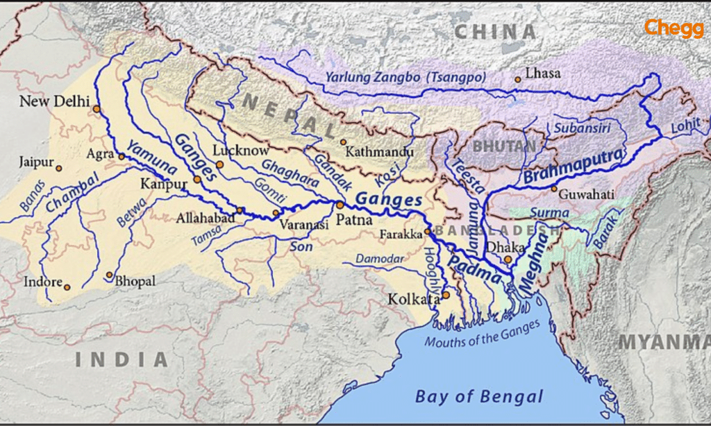
The expansive Ganga River System spans Bangladesh, Nepal, Tibet, and India, encompassing an impressive area of almost 10,86,000 square kilometres. Tributaries of Ganga, This vast river system constitutes nearly one-fourth of India’s total land area, representing the country’s largest river basin, covering an extensive 8,61,452 square kilometers.
The Ganga River System is one of the most significant river systems in India, both geographically and culturally. It primarily consists of the Ganga River and its tributaries of Ganga, which together form a vast and intricate network that supports millions of people and a diverse ecosystem. Here are some key points about the Ganga River System:
1. Source and Course:
The Ganga River originates from the Gangotri Glacier in the Himalayas, specifically at a place called Gaumukh in Uttarakhand.
It flows through several states, including Uttarakhand, Uttar Pradesh, Bihar, Jharkhand, and West Bengal, before emptying into the Bay of Bengal.
2. Major Tributaries:
The Ganga has several important tributaries, including:
Yamuna: One of its largest tributaries, it joins the Ganga at Allahabad (Prayagraj).
Gandak: Originates in Nepal and joins the Ganga in Bihar.
Kosi: Known for its changing course and flooding, it also merges with the Ganga in Bihar.
Ghaghara: Another significant tributary that flows from Tibet and joins the Ganga in Uttar Pradesh.
3. Cultural and Religious Significance:
The Ganga is considered sacred by Hindus and is often referred to as “Ganga Ma” (Mother Ganga). It is a central element in Hindu rituals, ceremonies, and festivals.
Many important pilgrimage sites, such as Haridwar, Varanasi, and Allahabad, are located along its banks.
4. Economic Importance:
The Ganga River System supports agriculture in the fertile plains of northern India, providing water for irrigation.
It also serves as a vital transportation route for goods and people.
5. Environmental Concerns:
The Ganga faces significant environmental challenges, including pollution from industrial waste, sewage, and religious offerings.
Efforts have been made to clean and preserve the river, including government initiatives like the “Namami Gange” program aimed at rejuvenating the Ganga and its tributaries.
6. Biodiversity:
The Ganga River System is home to a diverse range of flora and fauna, including the endangered Ganges river dolphin and various fish species.
7. Hydrology:
The river system plays a crucial role in the hydrology of the region, influencing the climate, groundwater recharge, and the ecosystem of the plains.
The Ganga Drainage System is a vast and complex network of rivers, tributaries, and streams that drain into the Ganga River, which is one of the most significant river systems in India. How many tributaries of the Ganga? This system plays a crucial role in the hydrology, ecology, and economy of the northern Indian plains tributaries of Ganga. Here are the key components and features of the Ganga Drainage System:
The Ganga River originates from the Gangotri Glacier in Uttarakhand and flows through several states, including Uttarakhand, Uttar Pradesh, Bihar, Jharkhand, and West Bengal, before emptying into the Bay of Bengal.
The river is approximately 2,525 kilometres (1,569 miles) long, making it one of the longest rivers in the world.
2. Major Tributaries:
The Ganga River has numerous tributaries that contribute to its flow. Some of the major tributaries of the Ganga include:
Yamuna: Originating from the Yamunotri Glacier, it is the largest tributary of the Ganga and joins it at Allahabad (Prayagraj).
Gandak: Originates in Nepal and flows through Bihar, joining the Ganga near Patna.
Kosi: Known for its unpredictable behaviour and flooding, it merges with the Ganga in Bihar.
Ghaghara: Flows from Tibet and joins the Ganga in Uttar Pradesh.
Saraswati: A seasonal river that is believed to be a tributary of the Ganga, although its existence is more mythological and historical.
Tons: A tributary that joins the Yamuna, which in turn feeds into the Ganga.
3. Geographical Features:
The Ganga Drainage System covers a vast area known as the Ganga Basin, which is characterized by fertile alluvial plains, making it one of the most agriculturally productive regions in India.
The basin spans several states and includes important cities such as Varanasi, Kanpur, Allahabad, Patna, and Kolkata.
4. Ecological Importance:
The Ganga River and its tributaries support a diverse range of flora and fauna, including several endangered species such as the Ganges river dolphin.
The river system provides habitats for various aquatic and terrestrial species and plays a vital role in maintaining the ecological balance of the region.
5. Cultural and Religious Significance:
The Ganga is considered sacred by Hindus and is often referred to as “Ganga Ma” (Mother Ganga). It is central to many religious rituals, pilgrimages, and festivals.
Numerous temples and ghats (riverfront steps) are situated along its banks, attracting millions of pilgrims and tourists.
6. Economic Significance:
The Ganga Drainage System is crucial for agriculture, as it provides irrigation to vast agricultural lands in the Ganga Basin.
It also supports fishing, transportation, and tourism, contributing significantly to the local and national economy.
7. Environmental Challenges:
The Ganga River faces severe pollution challenges due to industrial discharge, sewage, and religious offerings, which impact water quality and aquatic life.
Climate change, deforestation, and urbanization pose additional threats to the river and its ecosystem.
Government initiatives like the “Namami Gange” program aim to clean and preserve the Ganga, focusing on pollution reduction and sustainable development.
8. Hydrological Aspects:
The Ganga Drainage System is characterized by a monsoon-driven hydrology, with significant seasonal variations in flow. The river experiences heavy flooding during the monsoon season, which can lead to both benefits (fertile silt deposition) and challenges (flooding damage).
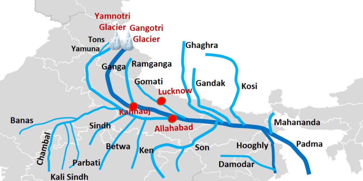
Ganga River System Map
Tributaries of Ganga: The Ganga River is spread over 286,000 sq. km in India, Tibet (China), Nepal, and Bangladesh. This river lies east in 73° 2′ and between 89° and 5’N. The Ganga River has a maximum length and width of about 1,543 km and 1,024 km, respectively. The Himalayas bound the river to the north, the Aravalli to the west, the Vindhya and Chotanagpur plains to the south, and the Brahmaputra Plateau to the eastern side of India. Numerous tributaries of the Ganga enhance its flow and contribute to its vast drainage system.
Four Main Tributaries of the Ganga
1. Alakhnanda River
Origin: The Alaknanda River originates at the confluence and feet of the Satopanth and Bhagirath glaciers in Uttarakhand. The triangular Lake Satopanth is situated at its origin.
Elevation: 4,402 meters above sea level.
Confluence Point: It meets the Bhagirathi River at Devprayag, where it is thereafter known as the Ganga.
Major tributaries: Alaknanda River include the Mandakini River, Nandakini River, and Pindar River.
Drainage Area: The Alaknanda River system drains parts of the Chamoli, Tehri, and Pauri districts of Uttarakhand.
2. Bhagirathi
Origin: The Bhagirathi River originates near Gaumukh at the base of the Gangotri Glacier, situated at the base of Chaukhamba Peak in Uttarkashi district, Uttarakhand.
Elevation: 3,892 meters above sea level.
Confluence Point: It joins the Alaknanda River at Devprayag, where the combined flow is thereafter known as the Ganga.
Major Tributaries: Various smaller streams and glacial tributaries in the upper watershed contribute to its flow; it also receives input from several tributaries along its course through the Himalayan terrain.
Drainage Area: The upper watershed of the Bhagirathi is dominated by glaciers, while its middle course flows through granite formations and deep gorges in the central axis of the Himalayas, primarily draining the Uttarkashi district of Uttarakhand.
3. Dhauliganga
Origin: The Dhauliganga River originates in the Dhauliganga Valley in the northern part of the Indian state of Uttarakhand.
Elevation: It originates from high-altitude Himalayan terrain.
Confluence Point: It joins the Alaknanda River near Vishnuprayag, contributing to one of the major headstreams of the Ganga.
Major Tributaries: The Dhauliganga is primarily fed by glacial and mountain streams; specific major tributaries are not detailed.
Drainage Area: The river flows through the state of Uttarakhand, playing a crucial ecological role by supporting biodiversity and habitat, controlling erosion, and regulating floods in the region.
4. Rishiganga River
Origin: The Rishi Ganga River originates from the Uttari Nanda Devi Glacier, located on the Nanda Devi Mountain in Uttarakhand.
Elevation: It originates from a high-altitude glacial region in the Chamoli district.
Confluence Point: It joins the Dhauliganga River near the settlement of Raini.
Major Tributaries: The river is primarily fed by glacial meltwaters.
Drainage Area: The Rishi Ganga flows through Chamoli district and passes through the Nanda Devi National Park, contributing significantly to the Ganga River system’s flow and ecological health.
Tributaries of River Ganga
The Ganga, an essential river in India, is nourished by around 17 major tributaries that are key players in managing water flow, storing monsoon rains, recharging groundwater, and transporting nutrients. On the left side, you’ll find important tributaries like the Ramganga, Gomti, Ghaghara, Gandak, Kosi, and Mahananda, while the right side boasts the Yamuna and Son, among others. These tributaries not only enhance the Ganga’s water system but also boost its ecological importance, making them crucial for grasping the river’s vital functions and its contributions to the environment.
Right Bank Tributaries of Ganga
Verify whether Yamuna is a Ganga tributary; explore eleven right-bank tributaries:
Yamuna: Yamuna is the largest tributary of the Ganga and one of the right bank tributaries of the Ganga. It originates from Yamuna glaciers that stretch 6316 km.
Son: Amarkantak plateau receives water from this Ganga tributary, forming waterfalls before entering Arrah.
Punpun: The Punpun River goes through Chatra, Aurangabad, Gaya, and Patna after rising in the Jharkhand region of Palamu.
Falgu: The Falgu, also known as Phagu, is the river that passes by the Bihar state district of Gaya. Another name for the Falgu River is the “Niranjana River.”
Kiul: The Kiul River rises in Jharkhand and is a tributary of the Ganga. This river, which is 110 kilometres long, drains roughly 16,500 km³.
Chandan: The Chandan River flows through the Bihar district of Bhagalpur. Locals call this river Champa because they founded a village called Champa along its banks.
Ajoy: The Ajoy, also known as the Ajay River in Jharkhand, rises from a small hill near Deoghar, roughly 300 meters high. The Ajay River flows through Bihar from Jharkhand to Simjuri in West Bengal. This is one of the tributaries of the river Ganga from west to east.
Damodar: The Ganga River’s major tributary is the Damodar. The Chhota Nagpur Plateau in the Bihar district of Palamau traces the origin of Damodar.
Rupnarayan: The Rupnarayan River rises in the Chhota Nagpur Plateau’s foothills at Dhalkisor and flows through Bankura, which merges with the Dwarkeshwar River.
Tamsa: It passes through the states of Madhya Pradesh and Uttar Pradesh. Tamsa River comes from the Kaimur range’s Tamkund.
Karamnasa: The Kaimur region is the source of this Ganga River tributary, which flows through the states of Uttar Pradesh and Bihar.
Left Bank Tributaries of Ganga
The six left-bank tributaries of River Ganga are given below:
Ramganga: The Ramganga tributary drains the southwest part of Kumaun and is one of the left-bank tributaries of the river Ganga. Its source is the Chamoli district of Uttarakhand, on the southern slopes of Dudhatoli Hill.
Garra: The Garra River flows through important industrial areas in the Uttar Pradesh district of Shahjahanpur.
Gomti: In Pilibhit, near Madho Tanda, is Gomti Taal, also known as Fulhaar Jheel. It is the source of the Gomti River. It passes over 900 kilometres of Uttar Pradesh before entering Ghazipur.
Ghaghara: The Ghaghara River rises from the glaciers at Mapchachungo. Tributaries of Ganga, It passes through the Himalayas of Nepal and meets the Sharada River at Brahma Ghats, India. Its length is 1080 kilometers. This river’s main tributaries are the Serja, Sharda, Rapt, and Chute Gandaki rivers.
Gandak: The Kali and Trisuli rivers, which have their source in Nepal’s massive Himalayan range, converge to form the Gandak River. It makes a meandering 765 kilometres until it meets the Ganga in Sonepur, near Patna.
Kosi: The Saptakoshi, with seven Himalayan tributaries, is a historic transboundary river traversing India and Nepal, joining the Ganga near Kursela.
Tributaries of the Brahmaputra
The Brahmaputra River, one of the major transboundary rivers of Asia, originates from the Angsi Glacier in Tibet, where it is called the Yarlung Tsangpo. Flowing through Tibet, India, and Bangladesh, it receives numerous tributaries that enhance its volume, biodiversity, and cultural significance. These tributaries are generally divided into northern and southern categories, based on the side of the Brahmaputra they join.
1. Northern (Right-Bank) Tributaries
These tributaries flow from the Himalayan ranges and carry snowmelt, making them perennial and high in volume.
Subansiri River – The largest tributary of the Brahmaputra in terms of discharge, originating from Tibet and entering Assam near Lakhimpur.
Kameng River – Known for its fast current, it flows through Arunachal Pradesh and joins the Brahmaputra near Tezpur.
Manas River – A UNESCO World Heritage Site region flows along the Bhutan–India border before meeting the Brahmaputra.
Jia Bharali River – Flows through Arunachal Pradesh and Assam, known for rafting and tourism.
Puthimari River – A smaller tributary joining near Guwahati.
2. Southern (Left-Bank) Tributaries
These tributaries rise from the hills of Nagaland, Meghalaya, and the Barak Valley, often seasonal with monsoon-fed flow.
Dhansiri River – Originates from Nagaland and flows into Assam before joining the Brahmaputra near Numaligarh.
Kopili River – Drains parts of Meghalaya and Assam; important for hydropower.
Digaru River – Flows from Meghalaya into Assam, mainly monsoon-fed.
Krishna River (local) – A smaller stream from Meghalaya joining in lower Assam.
Dibang River – Originates from Arunachal Pradesh, merges near Dibrugarh.
3. Tributaries in Bangladesh
When the Brahmaputra enters Bangladesh, it is called the Jamuna. There, it is joined by:
Teesta River – Originating in Sikkim, it’s the most important tributary in Bangladesh.
Atrai, Dharla, and Dudhkumar Rivers – Smaller rivers contributing to regional agriculture.
Hydrological & Economic Significance
Agriculture – The tributaries irrigate fertile plains of Assam and Bangladesh, enabling rice, tea, and jute cultivation.
Biodiversity – Rivers like the Manas and Subansiri support national parks and endangered species like the Gangetic river dolphin.
Flood Dynamics – Heavy monsoon flow from these tributaries often leads to seasonal flooding in Assam.
Tributaries of Ganga UPSC
Tributaries of Ganga or Ganga ki Sahayak Nadiyan is a crucial topic for UPSC. On November 4, 2008, Tributaries of Ganga, the Indian Prime Minister, Manmohan Singh, officially designated the Ganga River, also known as the Ganges River, as the nation’s official river.
The Ganga River, also known as the Ganges River, is the national river of India, a designation proclaimed by Indian Prime Minister Manmohan Singh on November 4, 2008. It flows through both India and Bangladesh, ultimately discharging into the Bay of Bengal after traversing the Himalayas and the Gangetic plains.
The river is deeply embedded in Indian cultural beliefs, with the widely held conviction that bathing in the Ganga washes away sins and channels salvation. Numerous holy sites are located along its banks, including Gangotri, Haridwar, Prayagraj, Varanasi, and Kali Ghat.
The Gangotri Glacier is the source of the Bhagirathi River, which is considered the origin of the Ganga. The Ghaghara River, which is the largest tributary of the Ganga, also originates from the Himalayas under the name Bhagirathi.
The Ganga Action Plan Phase I was initiated in June 1985 to address pollution and conservation of the river. Additionally, a cultural connection exists with the Ganga in Thailand, where the Siamese holiday “Loy Krathong” involves floating candles into rivers while praying to the Goddess Ganga.
National Mission for Clean Ganga
In June 2014, the Union Government designated the Navami Ganga Programmed as a “Flagship program for Tributaries of Ganga.” It has the dual goals of conserving and revitalizing the National River Ganga and effectively reducing pollution.
The National Mission for Clean Ganga (NMCG) and its state equivalent organizations, Tributaries of Ganga, the State Programmer Management Groups (SPMGs), are in charge of carrying out the program. The Union Government established the National Ganga Council (NMCG) in 2016 to oversee implementation, taking over from the National Ganga River Basin Authority (NRGBA). It comprises over 288 projects with a centrally supported, non-lapsable corpus of Rs. 20,000 crore.
Conclusion
The current administration has also been actively working to build dams in the Himalayan upper levels of the Ganga River in recent years. Concerns arise among experts that hydroelectric projects may negatively impact the flow of the Ganga.
As of 2019, 1,000 dams in the Ganga watershed were impeding the river’s ability to flow freely and causing continuous flow. Tributaries of Ganga: However, the issues remain unanswered when dams start to take on symbolic meaning in the development discourse. Continuous water flow requires careful consideration of the latest hydroelectric developments, particularly relying on the significant tributaries of the Ganga.
Frequently Asked Questions (FAQs)
What is the Ganga river system?
The Ganga River System covers approximately one-fourth of India’s total land area and is the largest river basin in the country, comprising nearly 8,61,452 square kilometres. Melting Himalayan snowfall, rain, and waters from tributaries feed the sacred river.
What are the two important drainage systems in India?
The Himalayan Rivers, which include the Indus, Ganga, and Brahmaputra, & their tributaries, and the certain Peninsular Rivers, which include the Godavari, Mahanadi, Cauvery, Krishna, Narmada, and Tapi, as well as their tributaries, are the two primary categories of India’s drainage systems.
Ganga originates from which state?
The Ganga River begins in Uttarakhand, and the Bhagirathi River is its headstream. Alaknanada has rejoined it. When glacier ice melts, the Bhagirathi River forms and flows down the Himalayas, merging with the Alakananda River to become the Ganges.
What is the mainstream of Ganga?
The Ganga originates in the Himalayas. However, Bhagirathi is the main Ganga source stream. It originates at Gaumukh from the Gangotri Glacier. The Ganga River’s headwaters comprise many tiny streams, mainly Pindar, Alaknanda, and Mandakini.
Which is the largest tributary of the Ganga?
The Yamuna River is the biggest tributary of the Ganga. It starts its journey from the Yamunotri Glacier in Uttarakhand and winds its way through bustling cities like Delhi and Agra, eventually joining the Ganga at Prayagraj (formerly known as Allahabad).
How many tributaries are there in Ganga?
The Ganga River has over 15 major tributaries, divided into Himalayan and Peninsular rivers. Notable tributaries include the Yamuna, Ghaghara, Gandak, Kosi, Son, and Chambal, all contributing to the river’s vast basin
What are the five headstreams of the Ganga?
The five primary Himalayan headstreams are: Alaknanda, Bhagirathi, Mandakini, Dhauliganga, and Pindar
Authored by, Muskan Gupta Content Curator
Muskan believes learning should feel like an adventure, not a chore. With years of experience in content creation and strategy, she specializes in educational topics, online earning opportunities, and general knowledge. She enjoys sharing her insights through blogs and articles that inform and inspire her readers. When she’s not writing, you’ll likely find her hopping between bookstores and bakeries, always in search of her next favorite read or treat.